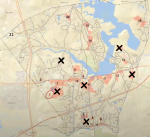
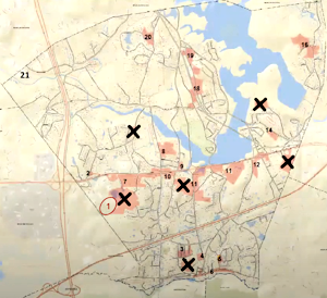
Above: The Planning Board discussed additions and deletions to the parcels that residents highlighted for consideration in Mapping Sessions last month. (image of map screened at Monday’s meeting, with my edits to show some of the changes discussed)
This week, the Planning Board discussed over 20 areas of town that residents had highlighted in mapping sessions might be good areas to overlay at least 50 acres of MBTA Communities zoning. They are working to determine which parcels to recommend be included in the overlay map. If passed by voters, the zoning would allow developers to build up to 15 housing units per acre in the mapped areas.
On Monday, the board worked out the process they plan to rank parcels. Based on some of the state’s restrictions and their own priorities, they also began weeding out some parcels, and adding a few for consideration.
As I’ve previously written, the state is mandating that the town add 50 acres of zoning that allows the denser housing by right. 10 acres must be within a 1/2 mile of the commuter rail station, and each acre must cover at least 5 contiguous acres. At Monday’s meeting, officials noted that at least one district must consist of 25 contiguous acres. (Read more details on the requirements here.)
Prior to Monday’s meeting, each board members scored the parcels identified in the mapping sessions based on a “rubric” using the following weighted criteria:
- 25% weight – Non-motor access to MBTA (safe walking or biking)
- 25% weight – Established infrastructure (water, sewer, utilities)
- 20% weight – Currently zoned Business or Industrial (less impact on residential neighborhoods)
- 10% weight – No traffic impact to local scenic roads/streets and neighborhoods
- 10% weight – Location will not require additional parking infrastructure at MBTA station
- 10% weight – No impact on trees
Fully meeting a criteria scored a 5 and not meeting it a 1. Higher scores would be considered more ideal.
During the meeting, members decided to add two additional criteria based on public comments — Road classifications and identified as priorities for Open Space preservation. The board didn’t discuss how the new criteria would impact the weighting system.
 At the meeting on Monday, the board quickly went through each parcel to discuss any issues related to lots that should be excluded. Any group of parcels that then fell under the minimum 5 contiguous acres was struck from consideration.*
The exclusions were mainly for properties that members identified as disqualified under the state regulations (e.g., deed restrictions, town owned property, and age restricted parcels). But the board also opted to preserve historic homes by eliminating from the map lots with houses built in the 1800s.
Members agreed that once the scoring is complete, they will evaluate the ranking of popularity of parcels within a 1/2 mile of the commuter rail station based on the feedback they received at the public mapping sessions.
Member Marnie Hoolihan proposed the initial criteria. She explained that the board didn’t have a way of scoring disbursement of the parcels to ensure they are spread out. But she assured that avoiding overburdening any area(s) of town would be part of their thinking.
Each member will rescore the revised map and submit their spreadsheets by the end of this week. The board will work on scheduling a meeting dedicated to working on the map. The board is working towards having a draft map and bylaw ready to open public hearings on in January.
For those interested, below are more details on the discussion.
Mixed Use
Prior to discussing MBTA zoning, the board heard from Economic Development Coordinator Leah Emerson. She brought forward the EDC’s interest in collaborating with the board to add mixed-use zoning on Route 9. She identified the easternmost and westernmost sections as the “gateway” points they would like to focus on. She highlighted that the zoning could comply with the MBTA Communities zoning.
Upon questioning about details recommended for zoning changes, Emerson said the EDC wanted to pursue a grant to bring in a consultant with technical expertise to help them come up with those.
Board members seemed receptive to the long term vision. But they were concerned about the timeline. Following their compliance schedule filed with the state he board needs to be ready with a draft bylaw for Annual Town Meeting in March. (Their backup if it fails at ATM is to consider changes and bring it to a Special Town Meeting in the fall.) Given the timeline, Emerson said the effort could be tabled until after the MBTA zoning. The board encouraged her to stay for the next discussion and for the EDC to provide input on the MBTA zoning.
Taking “popularity” of choices into account
Member Jesse Stein asked Hoolihan why she didn’t include in the criteria the number of times residents had voted for a parcel to be on the map. Hoolihan stated that she didn’t believe that had been properly tracked to avoid repeat votes from residents attending more than one workshop and worried that it would be biased. Resident Marianne Congdon-Hohman later asked for more clarity. She argued that the high turnout for residents near the train station reflected their concern. She believed that which choices were popular with them should at least be weighed into the decisions on the parcels within the 1/2 mile of the train station.
Member Debbie DeMuria pointed out that at least one table at the Mapping Session had decided not to cast votes. She believed that comments they heard from discussions at the table should be considered, not just the number of votes. Members agreed to take the public feedback from the sessions into account when they ranked that section of town.
Open Space Preservation consideration
Freddie Gillespie, Chair of the Open Space Preservation Commission, told the board that her commission had discussed the desire to protect parcels from the zoning that had previously been identified as priorities for Open Space preservation. She warned that if the parcels were zoned for high density housing, their values would rise and owners that might have been considering donating land would sell to developers. She asked the board to include that as one of their criteria for ranking.
Later, upon questioning, Gillespie explained that Mass Audubon conducted a study for the town and gave numerical rankings to prioritize which parcels the Town should pursue trying to preserve. She said she could provide those to the board. (I found the report on page 155 of the 2019 Open Space and Recreation Plan.) The board agreed to have that added to the scoring as a criteria.
Road Classifications
Resident Paul Carter recommended that to better represent the ability for parcels to handle traffic generated, the board should use numerical indicators for road classification. He explained that the state’s classifications would rank from high to low: Major Arterial (e.g., Route 9), Minor Arterial (e.g., Route 85), Collector Road (e.g., Parkerville Road), and Local Road (e.g., Flagg Road). Member Jesse Stein said he believed that was covered by criteria #4. But Hoolihan agreed with Carter and recommended adding the criteria.
Other concerns
Speaking as a resident, Gillespie worried about the impact on the town if too much of the commercial zoning identified on the map is converted to residential. She also opined the criteria was too weighted to prioritize parcels on the southside given 25% for walking/biking to the train station and another 10% avoiding parking at the station. She said they should avoid putting too much of the high density burden on any area of town. Hoolihan defended that when she scored parcels, she came up with only 2 high priority parcels in that area and another 2 on the northside of town. She said the board would be looking to spread out the zoning.
Carter’s recommendations included adding criteria that considered the likelihood of sidewalks being built in the future and the potential for transportation shuttle stops to the MBTA station. Hoolihan said she didn’t believe funding a shuttle would be passed by the Town. Carter argued that shuttles already pass by areas of town to get to and from the station. Board members said those possibilities would be too difficult to evaluate and score.
Resident Ashley Umbro responded to Hoolihan’s example scoring sheet that had been shared. In her opinion, Woodbury Road should be scored as not safe for walking (especially in the winter). She wanted to make sure members are actually going into the neighborhoods to understand rather than relying on maps. DeMuria said that Planning’s Business Admin Colleen Stansfield, who has been coordinating their efforts, has encouraged members to drive through each of the potential districts.
During the discussion of which parcels don’t qualify, DeMuria was concerned about including ones that are currently restricted under Chapter 61 for agriculture, forestry, etc.. The classification can be removed by the owner, as long as they agree to pay 10 years of back taxes — but there is a window after the change in which the Town would be given right of first refusal for purchasing the property. It isn’t under the category of permanent restrictions the state listed as disallowed under the regulations.
Update on compliance litigation
Although not mentioned in Planning’s discussion — in past public meetings, some residents have called for refusing to comply with the state’s mandate. Town officials agreed that the Planning Board would work towards complying with the law while other Town officials would keep an eye on other towns’ efforts to potentially push back on the regulations.
When the law was originally announced by the Baker administration, many towns focused on wording in the law that disallowed towns to take advantage of certain state grants if they “failed to comply” with the law. Since then, Attorney General Andrea Campbell warned that her office would take action against towns who fail to comply her reading of the law, which says doesn’t provide an opt-out option. The law states “An MBTA community shall have a zoning ordinance or by-law that provides for at least 1 district of reasonable size. . .”
The Town of Holden has not taken steps to comply with the law. A lawsuit was filed against Holden by the Central Massachusetts Housing Alliance and two state residents (from Westborough and Holden). A reader pointed me to a Telegram article covering that, this month, a Superior Court judge threw out the case for lack of standing by the Plaintiffs.
Although public officials publicly opposed complying and haven’t taken the initial required steps, according to the article, the Town hasn’t made an official decision to not comply since the AG issued the advisory:
According to a Monday news release from the town, Holden is still in the process of deciding whether it will “participate in the Commonwealth’s MBTA Communities Program.” Holden Town Manager Peter Lukes said in a statement that the town has received dozens of calls from residents and municipal leaders about where it stands.
The article doesn’t state whether the AG is yet planning any action against the town if it doesn’t meet upcoming deadlines.
*Planning staff will have to go through prioritized parcels to ensure that lots don’t have deed restrictions or other criteria that includes them from exclusion. But the Planning Board was able to quickly eliminate many that they were already familiar with as being 55+ housing, having single family home deed restrictions, etc.
Updated (12/13/23 11:39 am): I added subheaders and reorganized a few paragraphs in the latter half of the story to make it easier to read. I also added the second sentence under the “Update on compliance litigation”


