
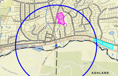
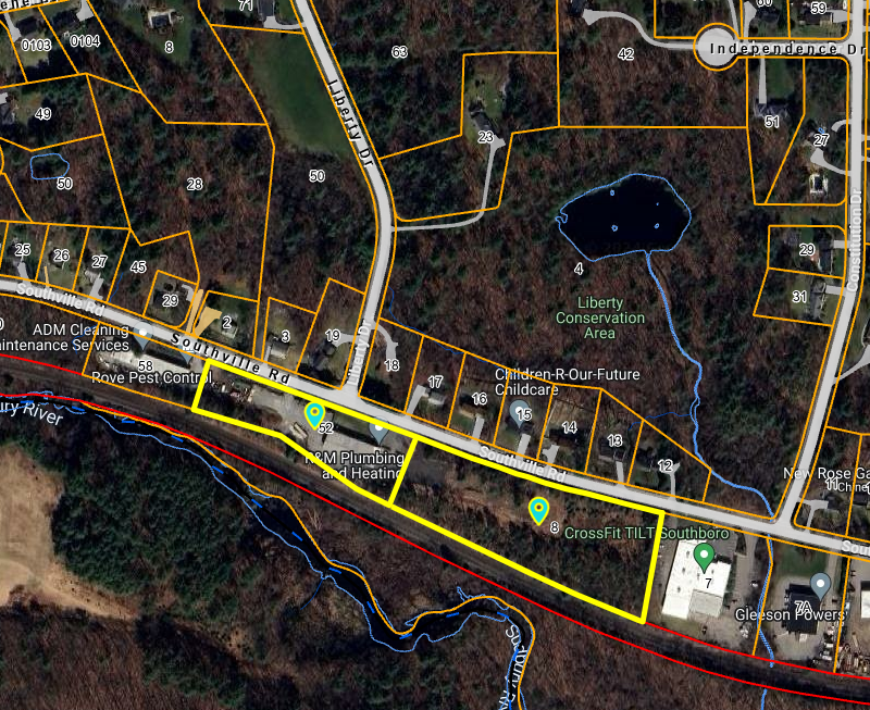
Above: MBTA Communities Zoning may be back on track to be voted on at a Town Meeting this year, with two new areas chosen for the section of town near the train station. (image cropped from contributed map)
On June 17th, the Planning Board voted to “put forward” new areas to be used for MBTA Zoning Overlay districts. The board will open hearings on the proposed map and zoning areas on Monday, July 22nd with hopes of bringing it to a Special Town Meeting on September 30th.
The proposed maps replace the district the board had previously proposed for Southborough’s southside.
The new zoning overlays would allow owners to develop up to 15 units per acre by right, as long as it complies with existing, underlying zoning laws (which cover setbacks, height, etc.)
It does not compel owners to make changes, and still allows for other future uses allowed in the zoning laws (like single family homes in the areas that are residentially zoned.)
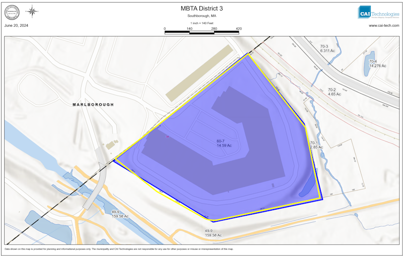
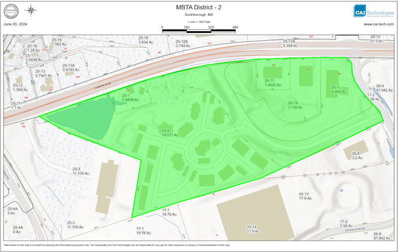
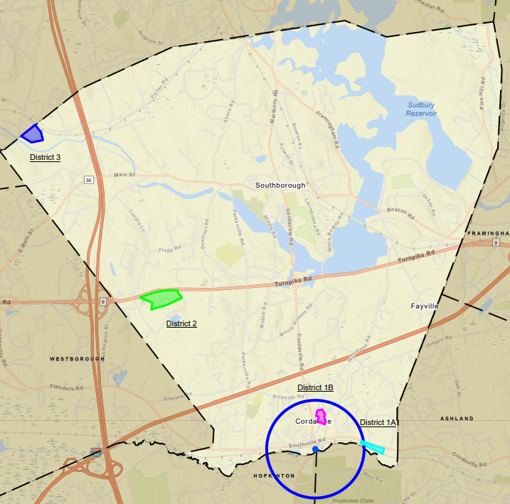 The newly identified parcels within a ½ mile of the Commuter Rail Station are in addition to the two unchanged parcels the board identified this winter on Route 9 and near the Marlborough border. (See image right.)
Members indicated that the districts aren’t set in stone, since they will solicit more public feedback through the hearing process.
Plus, their approval of the districts was conditioned on acceptance by the Executive Office of Housing and Livable Communities (HLC). That isn’t a sure thing, though the Chair seemed confident it will happen.
One of the two identified areas is outside of the map the state provided the Town for the ½ mile MBTA proximity requirement. And it is the requirement for that area the board was specifically seeking to meet.
As I’ve previously covered, the board had been working to bring a zoning law to Annual Town Meeting to comply with state requirements for towns with MBTA stations. That was derailed a month before the meeting when they learned that the map was non-compliant. It didn’t allow for enough potential by-right multi-unit buildings within the ½ mile area around the MBTA station.
The board has since taken a two-pronged approach to deal with the Town’s looming deadline of passing a zoning overlay bylaw by the end of 2024. They have lobbied for an extension while pursuing a new map to present to voters this fall.
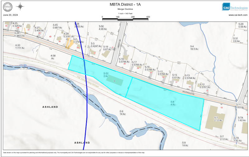 The maps approved on June 17th were broken into two areas. District “1A” is made up of two adjacent industrial-zoned lots. 30 Southville Road (parcel 52) is outside of the state’s mapped area but still within a ½ mile of the eastern border of the train station’s parking lot.
The board has been waiting to hear back from the Executive Office of Housing and Livable Communities (HLC) on a request they made this spring to shift the state’s mapped semicircle east.
In last week’s meeting, Chair Meme Lutrell sounded confident that parcels they selected would be accepted. She noted that Chris Kluchman (a Deputy Director at HLC) told them the agency was willing to be flexible. She was hopeful that not only, would they be able to use parcel 52, but also the lot to its east (parcel 8) which isn’t. Referring to the “merger doctrine”, she reiterated that both parcels are owned by the same company (Otey Brothers Realty).
During the meeting, Town Planner Karina Quinn noted that they had also asked HLC to relax the unit capacity required for the area near the station. She followed, “That one I don’t think is going over so big.”
The board’s recent decision incorporated feedback they solicited from residents living in the area of the train station. Postcards were mailed out to abutters, inviting them to participate in a mapping session on June 3rd.
At last week’s meeting, members described a good turnout with about nine tables, each with 6-8 people. Participants used stickers to identify where they thought the best places would be for the zoning overlays.
Participants were instructed that to meet the state’s requirements, the board was seeking to find:
- 10 acres total within the 1/2 mile semi-circle around the MBTA station
- Contiguous Areas (either one 10-acre or two minimum 5-acre districts)
- Unit capacity totalling at least 150 units (a spreadsheet provided the number of units each parcel could potentially produce)
Maps identified which lots were “non-conforming”. Those could be counted towards the acreage and to link up the contiguous areas, but they don’t count towards any of the units. (Parcels under 25,000 sqft are too small to allow any units under the existing underlying zoning. Buildings on the sites were grandfathered in before current zoning laws were passed.)
The maps also highlighted which parcels have historic homes/buildings and which lots are excluded from the zoning under the state’s regulations.
During the board’s discussion last week, Luttrell noted that a lot of the potential districts identified in the mapping session included historic buildings. She reminded that the board had said they were looking to avoid including those.
Recapping discussions residents had at tables on the meeting, members noted that most tables had prioritized Southville Road for the overlay. But a frequent discussion among participants was also apparently the desire to avoid putting too much of a burden on one single neighborhood. And board members worried about putting all of the zoning impact on the already busy road.
 Some tables purportedly discussed parcels that incorporated some property on Blendan Woods Drive but also property on other roads. After some discussion about the prioritization and feedback, the board settled on the residentially-zoned parcels identified in the map right.
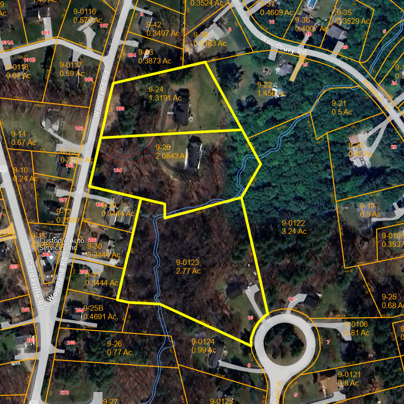 In the meeting, the section was shown as allowing up to 80 potential units under the calculation metrics. However, because the lots are already residentially developed, that kind of big change is unlikely to happen in the near term (if ever).
The board has received mixed feedback from the public as to whether they should zone to encourage development of housing projects. Some have criticized the board as seeming to be defying the state’s intent by tending to pick parcels that seem unlikely to be developed.
But others, have worried about a potential surge in development if the board takes another tact. Southside residents have publicly worried about the impact to their roads and neighborhoods. And some Town officials have warned about the potential impact to taxes and to the school building project.
 Last week, Planning member Lisa Braccio raised the latter concern about including the industrial parcel on Southville. Officials have previously pointed out that passing the zoning allowance for high density housing would promise a higher return for landowners than existing commercial/industrial use. Braccio warned that including the two parcels on easily lead to 77 units quickly being built there.
Member Marnie Hoolahan responded that adding those lots would be in keeping with the spirit of the state law seeking to increase available housing. She advocated for at least bringing it to public hearings, since many mapping session participants had pushed for the eastward shift. The board unanimously agreed.
For more background on the board’s selection of the other two MBTA zoning maps (pictured below), click here.
For more past coverage of the zoning initiative, click here.
