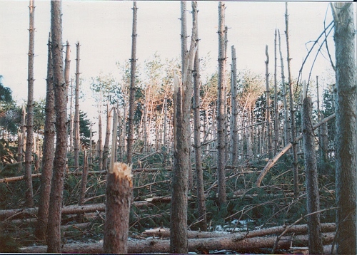
Above: 5 years ago, Southborough News shared “Photo above taken by former Southborough Tree Warden Skip Hubley”
A reader stumbled on to a tidbit – Tomorrow, March 29, 2014 will mark 30 years since a microburst within a Noreaster ravaged a 5 acre area of Red Pines in town.
Digging around, I found a story (and above photo) shared 5 years ago on the event by Southborough News:
Microburst on the former MDC property on Middle Road currently the new part of the Rural Cemetery. A strong micro burst hit Southborough leaving several acres of a red pine stand at a total loss. The following information taken today from the Wilmington Weather Examinor – 1984 A strong nor’easter battered New England. The central pressure of the storm dropped to 963 millibars (equivalent to a Category 3 hurricane) over the Atlantic east of New Jersey. Winds gusted to 108 mph at Blue Hill Observatory in Milton, MA and to 97 mph at Martha’s Vineyard. 8 to 16 inches of heavy wet snow fell in interior southern New England. Numerous thunderstorms also accompanied this spring blizzard. One thunderstorm produced a microburst at Southborough, MA which flattened about five acres of red pines; a most unusual occurrence for a nor’easter.
I have no memory of this storm. (Probably because it didn’t have a name!)
If you have memories to share, let us know in the comments.
Updated (3/28/14 6:30): Yikes! I was just telling my parents about this and redid my math. I guess it was wishful thinking that ’84 was only 20 years ago.
Now I’m dreading checking the comments.


Your math IS correct 1984 was 30 years ago!! And I do remember this event! Ch 5 weather forecaster Dick Albert talked about it and explained what a Microburst is.
My math is correct now because you missed the original “20 years ago” headline
I remember that microburst well. We have lived in Southborough since 1970. At that time we lived on the south side of Parkerville Road. I believe we saw an aerial picture showing the trees all in a circular twist but I have no memory of where we saw that picture.
I remember that storm well. We have lived in Southboough since 1970. At the time of the microburst we lived on the south end of Parkerville road. I remember seeing an aerial picture and it looked like the trees were all in twist but I can’t remember where we saw that picture.
I remember it well. We live on the other side of the causeway from where it happened.
I grabbed my camera and went over to take pictures. Finished up. Climbed on to the stone wall, jumped off and landed in the loosely packed sand the highway department leaves there for the little parking spot. Jump was good, landing resulted in torn fibers in the tendon in my right ankle. Was on crutches for quite awhile!
Love the “jump was good”. Those things are always funnier in retrospect.
Of course the important thing is – did you manage to get any good pictures?