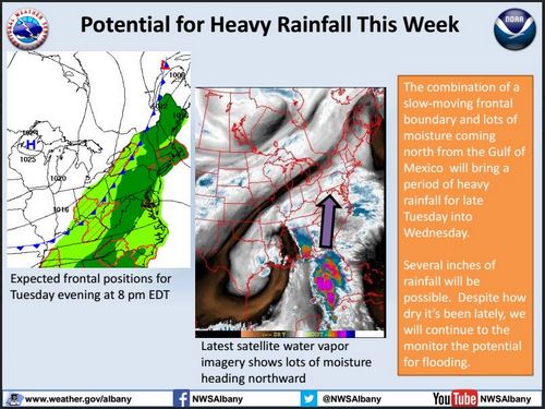
Above: Make sure your prepared for rain deluges starting tonight, with potential for flash flooding over the weekend. (Image from National Weather Service)
Southborough Emergency Management asked me to share a warning. With expected rain deluges today and tomorrow, there is reasonable concern for flooded basements. And as we approach the weekend they are keeping an eye on potential for flash flooding of streets.
Today is the time to take your own personal preparedness steps including; flood prevention/mitigation (especially in basements), keeping phones charged, reviewing your preparedness plans and kits, etc. If you have not already, sign up for the Town’s emergency notification system (CodeRED) – info at www.southboroughtown.com, “LIKE” the Southborough Emergency Management Agency Facebook Page and “FOLLOW” the Town of Southborough on Twitter “@17Common”. These mediums will be used to disseminate ongoing information.
Lastly – but probably the most important safety reminder is to NOT drive through flooded streets. As little as 2 inches of water can sweep a vehicle away. Remember the saying “Turn around Don’t Drown”.
One item that’s good to know in times of potential emergency, thanks to SEMA our town was recently acknowledged “Storm Ready” by the National Weather Service. You can read about that here.
You can read SEMA’s full statement and attachments about this week’s weather below:
Lengthy but vital initial information regarding upcoming storms and hazards – please read all.
The good news is we will finally get some greatly needed rain, the bad news is that the amount we need will come as two deluge storms over the next few days. As such there is a high potential for urban and inland flooding.
The first round will come through Tuesday night through late Wednesday, dropping a widespread 2” of rain with pockets of up to 5”. This amount of rain combined with the bone dry ground will lead to localized flooding from runoff. The early stages will be similar to when we get heavy rain in late winter when the ground is still frozen. The runoff will follow the path of least resistance, which is often the lowest point (i.e. basements).
To compound Wednesday’s storm, Tropical Storm Joaquin will drop significantly more moisture around Sunday/Monday. This is something to keep a VERY close eye on. The most recent track this morning has it tracking back eastward towards Connecticut (see image below) – BUT this is still many days out and the track can shift east or west. Joaquin has also slowed down some, which is allowing it to gain more strength and moisture – HOWEVER he will accelerate northward rapidly at some point over the weekend. In addition to the rain, winds will impact the area threating to down/uprooted trees from the statured ground. Coastal flooding and erosion are also VERY serious threats.
As a reminder, Irene in 2011 was also a Tropical Storm. TS Joaquin is slightly weaker but has the same potential to cause massive and dangerous flooding in the hardest hit areas. Western Ma and Vermont were the targets for Irene. Joaquin’s targets are yet to be determined.
SEMA will continue to monitor both storms and their potential impacts. We will send out additional updates and any pre-planning/EOC activations during the week/end. Everyone should also monitor the storms through local weather forecasts and the National Hurricane Center at http://www.nhc.noaa.gov/.
Today is the time to take your own personal preparedness steps including; flood prevention/mitigation (especially in basements), keeping phones charged, reviewing your preparedness plans and kits, etc. If you have not already, sign up for the Town’s emergency notification system (CodeRED) – info at www.southboroughtown.com, “LIKE” the Southborough Emergency Management Agency Facebook Page and “FOLLOW” the Town of Southborough on Twitter “@17Common”. These mediums will be used to disseminate ongoing information.
Lastly – but probably the most important safety reminder is to NOT drive through flooded streets. As little as 2 inches of water can sweep a vehicle away. Remember the saying “Turn around Don’t Drown”.
[Attached] are:
- TS Joaquin’s storm track as of 6am – Tuesday
- Situational Weather Hazard statement from MEMA & the NWS
- (Attached): Flood potential graph and NWS weather update
Be Smart / Be Safe
Lt. Neal P. Aspesi
Southborough Fire Department
Southborough Emergency Management


